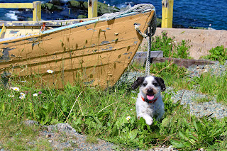
July 16th: from my viewpoint at Pouch Cove, at the tip of the Avalon Peninsula near St. John's, Newfoundland, it appeared that Sparky and I had reached the end of Canada.
 |
| Just open ocean between here and Europe |
However, Cape Spear, a headland located a little south of St. John's at a longitude of 52°37' W, is the easternmost point in Canada and North America, excluding Greenland. We were close at a longitude of 52°77' and all I could see was the open ocean. The next piece of land would be England? Or France?
Established in 1611, Pouch Cove is a tiny, roundish, steep-sided cove shaped like a pouch. The locals store their personal boats on a ridiculously steep incline. I had vertigo just standing at the top of the ramp, trying to take a photograph.We are staying in the capital city of St. John's for three days at a hotel in the harbour and within walking distance of the famous "Jelly Bean Row". I am looking forward to roaming the streets and photographing the dozens of colourful row houses.
Cheers, Lynda and The Sparkinator
 |
| Looking down the boat ramp |
 |
| The Sparkinator at Pouch Cove, NL |
 |
| Close up of whatever this is. |
 |
No clue what this is!
|


.jpg)


No comments:
Post a Comment